I tried to use hey whats that to see if it could tell what that mountain(s) are, I guessed wrongly but the photographer has put me right to say that they are the Slieve na Calliagh Mountains 23 miles NW from the Hill of Tara?
Friday 14 September 2007
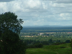
View from Cormac's rath across Skryne valley.
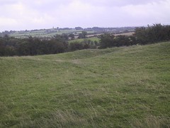
good picture see the tower in the distance
ooh my first flickr to blogger post, very smooth.
Here's a map of Meath with all the photos of tara geotagged on it.
ooh my first flickr to blogger post, very smooth.
Here's a map of Meath with all the photos of tara geotagged on it.
Monday 10 September 2007
More mapping info on tara
googlemapsmania one of the main mapping blogs on the web included my page in a post, thanks to them hopefully more people will hear about the threat to Tara.
They also had a link to LookAroundIreland. A site using interactive photo panoramas and googlemaps to show tourist and heritage spots around Ireland. Including Tara and Liafail. Also a fantastic panorama from the central chamber of Newgrange.
I don't know how long this has been around on www.archaeology.ie It is live Record of Monuments and Places map... you can zoom in anywhere in Ireland to see archaeological features on detailed map, highlight them with a box and then it will list what they are, unfortunately it doesn't actually give the name of the specific feature only the type like 'hilltop fort' or ''barrow.
They still don't seem to have a straight list of national monuments available on the web. the one on the OPW site was taken down because they said there were too many errors on it.

Aerial photos of Ireland are available at the National Parks and wildlife service website for Ireland, I don't know how much of Ireland they cover but I seen numerous areas which are better quality and more recent then googlemaps. It primarily shows special conservation areas with aerial photos overlayed with contours.
I've already mentioned Megalithmania and the Modern Antiquarian.
Megalithomania Reports on numerous archaeological sites in Ireland with additional geographic information. You can view notes, photos and then view it place marked in googlemaps and search to view other megaliths in the area.
The Modern Antiquarian uses a similar system Juliana Cope's online personal antiquarian guide. I also discovered their own downloadable kmls for googleearth, with all the sites marked with a photo popping up beside aswell. Even has google v4 and v3 version

Subscribe to:
Posts (Atom)
